June 22, 2020
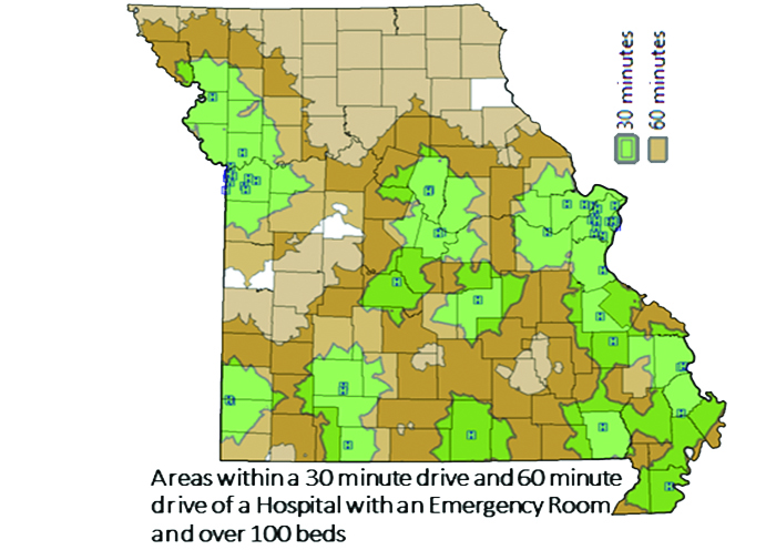
This image from Professor Chi-Ren Shyu’s work shows the distance between Missouri communities and nearest hospitals.
Planning ahead for a pandemic—or any disaster situation—is costly and complex. Now, Mizzou researchers are hoping to take the guesswork out of it for Missouri’s smaller communities.
The catalyst for the research is COVID-19. In spite of a months-long statewide shutdown, much of rural Missouri remains vulnerable to a second wave of the virus. The project will involve collecting large amounts of geospatial data—or data based on location—then analyzing that data to predict outcomes. Those prediction models will help local leaders make informed decisions if the pandemic worsens in their communities.
Chi-Ren Shyu
“The information we will collect and our results will help better plan how we respond to this type of outbreak in our rural communities,” said Chi-Ren Shyu, who is leading the project. “Our end goal is to provide a dashboard that will have not only statistics, but also recommendations.”
Shyu is director of MU Institute for Data Science and Informatics and a professor of electrical engineering and computer science. He is collaborating with researchers from MU’s School of Medicine and College of Arts and Science. The team received a one-year RAPID grant from the National Science Foundation for the work.
Planning Ahead
The first step to crafting a disaster response plan is having an inventory of location-specific resources, such as health care facilities and supplies. Shyu, along with Tim Haithcoat, deputy director for the Center for Geospatial Intelligence, had already begun that work with support from the UM System’s Research and Creative Work Strategic Investment Program.
But having that information isn’t enough. Local leaders need to know how to use the information. And coordinating response efforts across geographic lines can be tricky, said Associate Professor Tim Matisziw. Even if two towns agree on a plan, taking action can have unintended consequences.
For instance, one community might have adequate, unused supplies. But if that community shares with a neighboring town, what happens if it suddenly needs those supplies back? Someone may have to travel to another area to seek medical care for COVID-19. But even if care is available there, that person could be putting the other community at risk.
“There are always trade-offs when you try to manage resources and determine who gets them,” Matisziw said. “One thing we’re trying to do is help with the logistics. We want to figure out the most efficient way to move resources where they’re needed, to minimize the spread of disease and costs.”
Using Data to Predict Outcomes
Matisziw has joint appointments in the Department of Civil and Environmental Engineering and the Department of Geography. For this project, he and fellow researchers will use the data to predict potential scenarios and outcomes. For instance, what could happen when communities return to pre-COVID routines.
“We want to build mathematical and computational models to look at how the virus spreads through human interactions and social gatherings,” Shyu said. “Schools are closed now, but how about in the fall? Even though you have social distancing, there could be issues at sporting events and other activities. We want to predict what would happen and what resources are available when the next wave of the outbreak comes.”
Broader Implications
While the grant specifically addresses COVID-19, the database will benefit communities during any type of crisis. In Missouri, that includes tornados, floods and earthquakes along the New Madrid fault line. Those types of situations become worse if we aren’t prepared.
“Think about Hurricane Katrina,” Matisziw said. “The population was displaced. Resources didn’t come in time. FEMA trucks were stationed states away with no marching orders, That’s the type of situation we’re looking to avoid. We’re looking for a more coordinated response.”
The team will deliver results of the project to clinicians, policymakers and first responders across rural Missouri.
The research group also includes:
Giovanna Guidoboni, professor of electrical engineering and computer science and a mathematics professor, who will help with mathematical models;
Henry Wan, professor of electrical engineering and computer science with joint appointments in the School of Medicine and College of Veterinary Medicine, who will also assist with prediction models;
Physicians Richard Hammer and Salman Ahmad, who will bring first-hand experience for COVID-19 testing and intensive care; and
Mirna Becevic, who will address the needs from the field through the Missouri Telehealth Network.
In addition, the research team will work closely with Jim Watkins, coordinator of Region E. Community Emergency Response Team. That team is part of FEMA’s National CERT Program to provide standardized emergency response training to communities within a particular region.